mail_outline sales@mediastorehouse.com
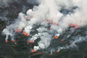
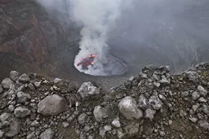
Lava lake Nyiragongo with lava meltings and fountains - Congo, Democratic Republic, North Kivu, Virunga Mountains, Nyiragongo, crater edge - Great Rift Valley, Albertine Rift, Virunga National Park
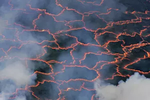
Lava lake Nyiragongo with glowing lava meltings - Congo, Democratic Republic, North Kivu, Virunga Mountains, Nyiragongo, crater edge - Great Rift Valley, Albertine Rift, Virunga National Park
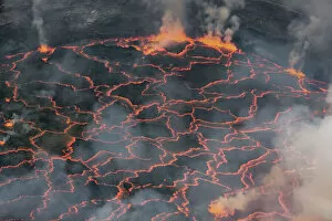
Lava lake Nyiragongo with glowing lava - Congo, Democratic Republic, North Kivu, Virunga Mountains, Nyiragongo, crater edge - Great Rift Valley, Albertine Rift, Virunga National Park
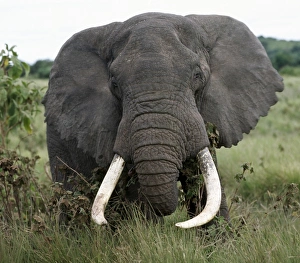
A fine bull elephant, Ngorongoro CraterA fine bull elephant feeds along the rim of the world famous Ngorongoro Crater. The craters 102-square-mile floor and the surrounding highlands are spectacular for wildlife
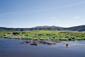
Hippos wallow in a lake in the Ngorongoro CraterHippos wallow in a small freshwater lake on the floor of the world famous Ngorongoro Crater. The craters 102-square-mile floor is spectacular for wildlife
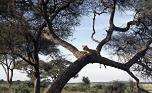
A lioness keeps watch, Tarangire National ParkA lioness keeps watch from a comfortable perch in a huge Acacia tortilis tree in the Tarangire National Park
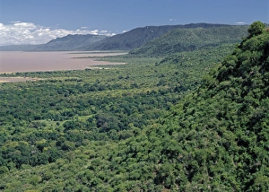
Western wall of the Great Rift Valley above Lake ManyaraA section of the western wall of the Gregory Rift (a part of the eastern branch of the Africas Great Rift Valley) above Lake Manyara, a shallow alkaline lake
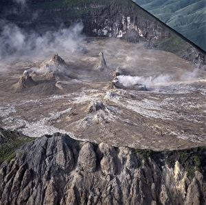
Ol doinyo Lengai, The Msais Mountain of God, is the only active volcano in the Gregory Rift - an important section of the eastern branch of Africas Great Rift Valley
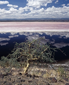
Lake Natron in the Rift ValleyLake Natron in northern Tanzania is one of the most alkaline of the Rift system. As its waters evaporate in the intense heat, sodium sesquicarbonate, known as trona or natron
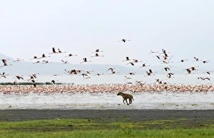
A spotted hyena chases lesser flamingos on the shoreline of Lake Nakuru, Kenya
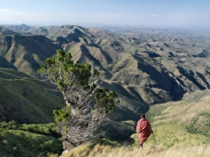
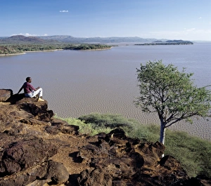
A Samburu warrior looks out over a vast expanse of inhospitable country from the eastern scarp of Africas Great Rift Valley at Losiolo, north of Maralal
The alkaline waters of the seasonal Lake Logipi, situated at the northern end of the Suguta Valley, are a favourite haunt of lesser flamingos because the blue-green algae upon which they feed grows
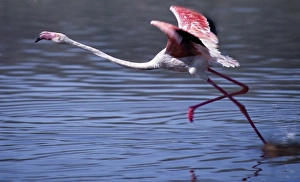
A greater flamingo takes off from the alkaline waters of Lake Bogoria. This Rift Valley lake is a favourite haunt of both greater
Lake Baringo is one of two freshwater lakes of the Eastern Rift Valley. Its waters are red with suspended solids due to bad soil erosion in its catchment area
A Msai warrior speaks on his mobile phone from the saddle of his camel near Lake Magadi in Kenyas Rift Valley Province. Mobile phones are a popular method of communicating with family
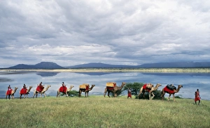
Msai men lead a camel caravan laden with equipment for a fly camp (a small temporary camp) past Lake Magadi. Clouds hang low over the Nguruman Escarpment (a western wall of the Great Rift Valley)
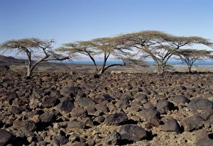
Lava boulders cover vast tracts of infertile land on the eastern side of Lake Turkana. Often referred to as the Jade Sea due to its distinctive colour, Lake Turkana is a true desert lake
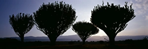
A fine stand of Euphorbia trees (Euphorbia candelabrum) with the Mau Escarpment _ a western wall of the Gregory Rift _ in the background
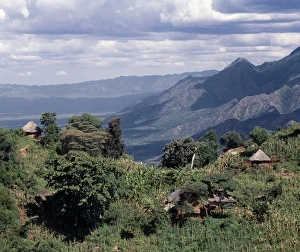
Traditional thatched homesteads perched on top of the fertile Tugen Hills, looking across the Kerio Valley to the western scarp of the Gregory Rift (the Keiyo Escarpment)
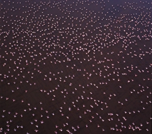
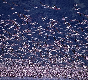
Lesser flamingos (Phoeiniconaias minor) in flight over Lake Nakuru, an alkaline lake of the Rift Valley system where tens of thousands of them may be seen lining the shores for many months of the year
A hardy Commiphora tree thrives beside Lake Magadi, an alkaline lake of the Rift Valley system, situated in a vey hot region of southern Kenya
Donkeys are indispensable beast of burden, assuring the nomadic Turkana of complete mobility. These study little animals carry the few essentials of life in oval panniers strapped to their flanks
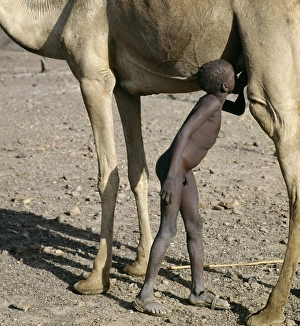
A young Turkana herdsboy sneaks a drink of milk straight from a camels udder. Camels are important to stockowners in the arid regions of Turkanaland since they are browsers
As the sun rises above the forested peaks of Mount Nyiru, members of a Turkana family chat and plan their days activities
As weeks without rain turn into months, the vegetation of the semi-arid thorn scrub country of south Turkana district begins to turn brown and many trees shed their leaves
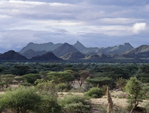
At the onset of rain, thorn trees burst into leaf and the vegetation of the semi-arid countryside looks fresh and green for a while. The sharp peak of the impressive mountain range is called Kakurotom
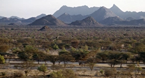
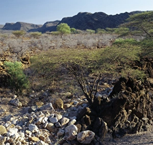
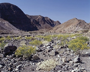
Inhospitable, semi-arid, thorn scrub country northwest of Lodwar, the administrative centre of the Turkana people. All the hills and mountains are of volcanic origin
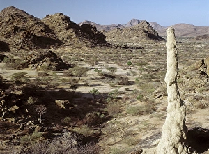
Semi-arid, thorn scrub country, littered with lava debris, near Parkati. Being extremely hot and dry, the area is only used by the nomadic Turkana for grazing goats and camels
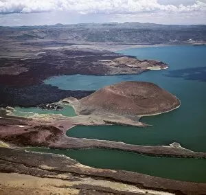
An aerial view of the southern end of Lake Turkana, which is named Von H_hnel Bay after the Austrian naval officer who was part of an epic journey of exploration to reach the lake in 1888
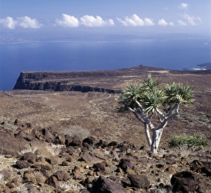
On the inhospitable lava-strewn hills surrounding the inlet of Ghoubbet el Khar‰ b (the Devils Throat), a relative of the Dragons Blood Tree (Dracaena orbet)
After a rain shower, shrubs of the Pea family (Papilionoideae) give a splash of colour to the forbidding landscape near Ghoubbet el Kharab (the Devils Throat)